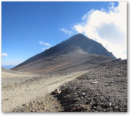
Notice two tiny peaks - the one on the left (South side) is the true peak.
Some History:
Mt. Tom (13,658 ft) is a massive mountain rising at the eastern edge of the Sierra, just West of Bishop, CA. One can't drive by it on Highway 395 without noticing its dominating presence and, if you are a climber or peak bagger, you will immediately set your sights on it.
The mountain was named for Thomas Clark, a resident of the pioneer town of Owensville, who is credited to be the first to climb it in the 1860s. Mt. Tom and Mt. Morgan were part of the Pine Creek mining operation which was an important producer of Tungsten during much of the 20th century. You will see remnants of these mines when climbing the peak. The ore deposits are now largely depleted and the mines have closed.
The most common route up the mountain starts with a one night backpacking trip up Horton Creek Canyon to Horton Lake, a 3.6 mile hike with about 2,000 feet of elevation gain. Getting to the trail head is another matter and requires, at minimum, a high clearance vehicle.
You start by heading West on highway 168 from downtown Bishop. When you reach Buttermilk Road (also called 7S101,about 13 Km from Bishop, coordinates 37.335250, -118.515700), you exit to the right and continue West along a dirt road for about 7.3 total miles or 12 Km. You will see many side roads and turn outs, just continue on the main road. You will see great views of Mt. Humphreys, Basin Mountain and to the right, Mt. Tom. Eventually, after about 6 miles, you will get to a side road that goes to the right. There should be a sign there that says "Horton Lakes TH" (coordinates 37.308683, -118.608983). You will travel on this side road for another 1.3 miles. In 2013, when I drove in (Ford Ranger 4X4), the road became progressively worse and it took about an hour to get from Bishop to the locked gate at the trail head. There are a few turnouts and parking spots right near the gate if your car can make it that far, otherwise, park where you can off the road and hike the remaining distance.
The trail head is at 2440 m or about 8000 ft., (GPS coordinates 37.312167, -118.624850)
From the locked access gate, continue on by hiking the old road / path to the Northwest (there are no side trails). You will soon reach a beautiful valley flanked by Basin Mtn on your left and Mt. Tom on your right- Cross a wooden bridge, a creek flows here. After about 4 miles from the gate, you will reach Horton Lake. There you will see two cabins and an old ore chute (37.319251, -118.663394). There are some spots near the cabins for camping but the best location is down below the cabins toward the lake.
You will want to get an early start on the mountain. There will be no water after you leave Horton Lake. I packed 2 liters for the hike up. Go back up past the cabins to where the trail forks and head West on the upper trail. You will soon encounter many switchbacks (they say about 16). Watch the trail closely as there has been some landslides recently and you will have to cross over one or two of these sections. In 2013, the switchback trail was not dangerous, just follow the path as best you can and don't cut the switchbacks.
Horton Lake is at about 10,100 feet. The top of the switchbacks at about 11,600 ft. It took me about 2 hours to get up there (ok, I was slow!). At the top of the switchbacks, the scenery opens up to an enormous open valley, devoid of trees and vegetation. It is called "Hanging Valley". You will see some old mines down in the valley on your left, Mt. Tom on your right. An old mining road circles the Western flank of the mountain and slowly gains altitude. Follow this road.
Some people head up the rocks soon and follow the ridge line toward the peak. I do not recommend this. Just stay on the road for about a mile. The road turns into a path and dead ends at the Hanging Valley tungsten mine. There will be machinery and an old mine entrance - The mine is dangerous, do not enter. In a heavy snow year, you might encounter left over snow on the shady section of trail, about 400 meters before the mine. If it is icy and you do not have an ice axe, it will be a hairy traverse. If you encounter this, consider hiking up from there and traversing over to the chute above the mine. Your altitude is now about 12,000 ft and you have about 1,600 feet of loose rock and scree ahead. Hiking poles really help!
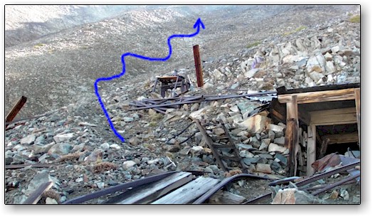 The old mine and the faint trail.
A trail heads up to the immediate left of the mine entrance. Take it. Follow the faint trail as best you can. It switchbacks up the mountain over scree and boulders, generally, it heads up the chute above the mine. Mostly class 2 but maybe some class 3, depending on your route. But, near the top, you will have to move left (North) two chutes over to get to the summit. I headed up toward a predominant rock I called the "nipple" (shown in the image below on the right). To the right of the nipple was a straight drop off, so I had to traverse to the left of it two chutes over where I found an easy straight shot up to the summit. I reached an area between the two peaks. The peak on your right (South side) is the true summit. There you will find the register.
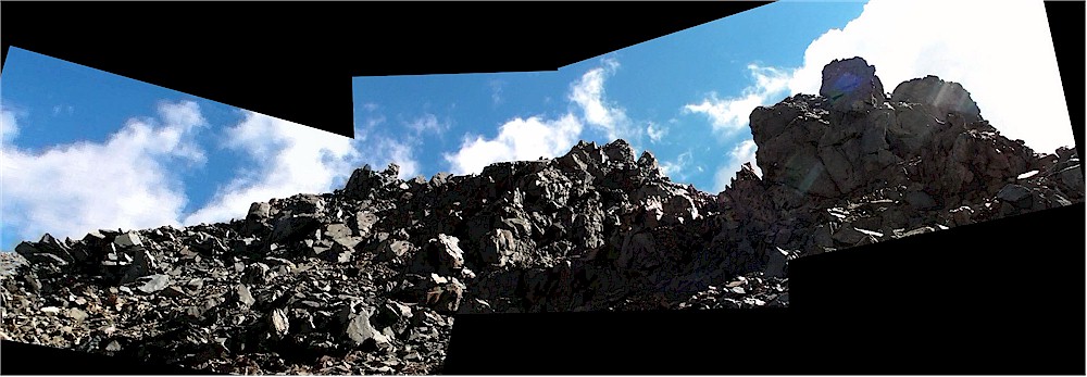
Image above taken at about 13,100 ft, what I saw after climbing up the chute. If you find yourself here, traverse left. You are almost there!
The summit coordinates: 37.338611, -118.658333 (may not be accurate)
Getting down is a bit more of a challenge - Uggggh! Best to follow your route up as the main chute below the summit is steep and dangerous with a lot of loose rock. It is difficult to see the mine from above but just carefully work your way back down until you reach the mine or the road then just follow it out to the switchback area. I kicked one big rock loose (about the size of 4 watermelons) and it went all the way down into the valley. On the down climb, I also took a fall, bent a pole and skinned my arm - all part of the adventure!
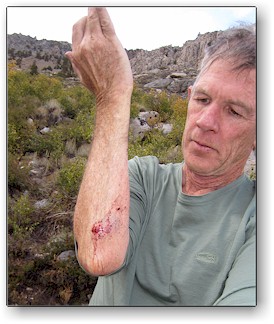 Battle scars |
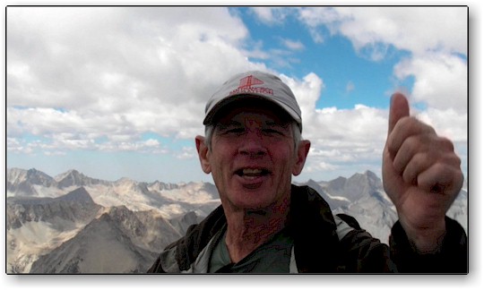 Finally, Finally! |
The round trip hike from the locked gate trail head is about 7.5 miles each way with about 6,000 feet of vertical gain. It can be done by very fit people in a day but allow for one long day. From Horton Lakes, it took me 5 1/2 hours up and 3 hours back - then an additional 2 hours to hike back to the car. I was at the car at 6 pm. I could have done the entire route in about 13-14 hours (again, I am out of shape and drove up from sea level) - A very fit, acclimated person might be able to do the round trip in 7-8 hours.
Here is a link to our first attempt in 2006 (on YouTube). We tried to hike it all in one day. Turned back at 2pm when it started snowing.
Second attempt was in 2011, we were in excellent shape from our PCT hike and camped at Horton Lake but, again, we were turned away because of residual snow from the big snow year - it covered part of the trail and would have made a traverse very dangerous.
Finally, on Sept. 13, 2013, Barb was visiting relatives and Jack conquered the summit. See the video here.
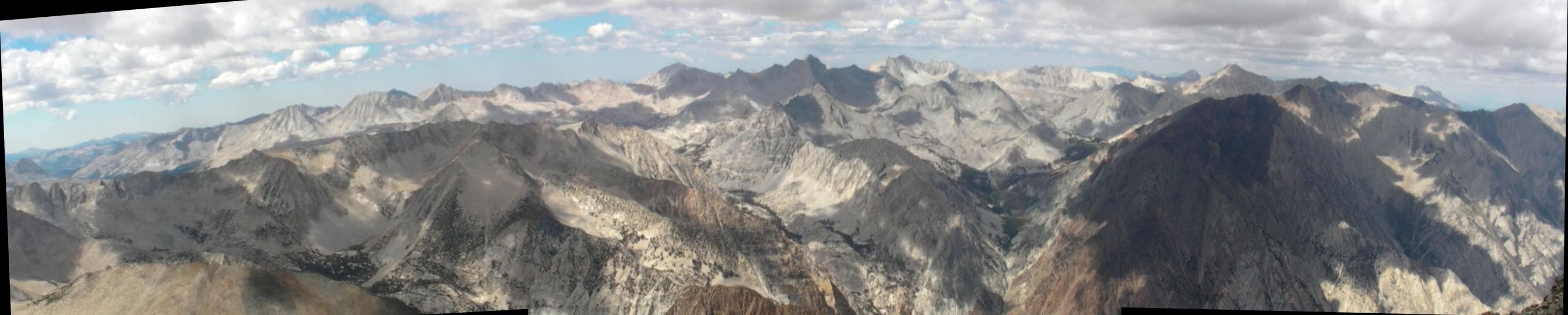
View looking North and West